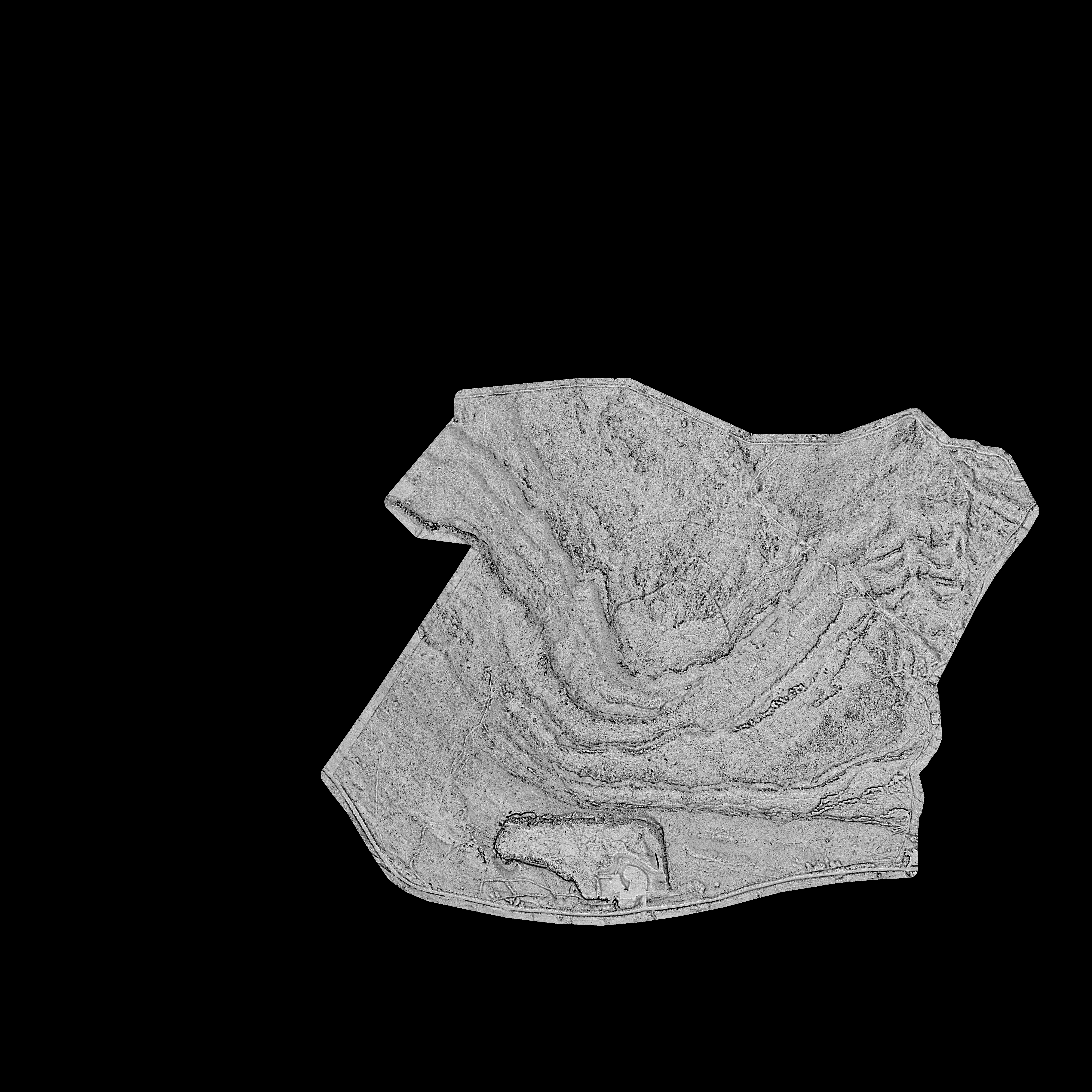
Warton Crag: Historic England LIDAR Image #4 of 7 zoomHistoric England LIDAR Image #4 of 7 (JPG format)Historic England#4 of 7 Historic England vertical LIDAR images of Warton Crag. Each image uses different processing and effects to help identify features and detail.Creator Historic England Date created 09/06/2016 Time period c.bc3000 - c.200 Contributor Morecambe Bay Partnership Copyright Historic England Access Open Reference number H2H.0169 Format LiDAR survey (24) Themes Natural landscape (149)Warton Crag (52) Places Warton (53) No CommentsStart the ball rolling by posting a comment on this page! Add a comment about this pageYour email address will not be published. Required fields are marked *Your comment:Name * Email * I consent to my name and e-mail address being stored along with this comment, and to the website editors communicating with me by e-mail about the comment if necessary. My name may be published alongside the comment on the website, but my e-mail address will not be published. My information will not be shared with any third party (see our Privacy Statement - opens in a new window). * Δ Natural landscape120 x Site Images and Notes from Photographic Archaeological Survey of Warton Crag between 2013 - 2018 by White Cross Archaeology Group1788 Hutchinson drawing of Warton Crag HillfortA 3D model of the enclosure site on Birkrigg Common, near Urswick, Ulverston.A 3D model of the enclosure site on Birkrigg Common, near Urswick, Ulverston.A film showing showing the stone circle on Birkrigg Common, near Urswick, Ulverston, after bracken clearing.A film showing volunteers clearing bracken on Birkrigg Common, near Urswick, Ulverston, in September 2016 (long version).A film showing volunteers clearing bracken on Birkrigg Common, near Urswick, Ulverston, in September 2016 (short version)A film showing volunteers clearing bracken on Birkrigg Common, near Urswick, Ulverston, in September 2016 (short version).A Lofty Conical EminenceAn aerial view of the enclosure on Birkrigg Common, near Urswick, Ulverston, before bracken clearing.An aerial view (wide) of the enclosure on Birkrigg Common, near Urswick, Ulverston, before bracken clearing.An aerial view (wide) of the stone circle on Birkrigg Common, near Urswick, Ulverston, before bracken clearing.An aerial view of a Round Cairn (wide) on Birkrigg Common, near Urswick, Ulverston.An aerial view of a Round Cairn on Birkrigg Common, near Urswick, Ulverston.An aerial view of the enclosure on Birkrigg Common, near Urswick, Ulverston, after bracken clearing.An aerial view of the enclosure on Birkrigg Common, near Urswick, Ulverston, after bracken clearance.An aerial view of the enclosure on Birkrigg Common, near Urswick, Ulverston, after bracken clearing.An aerial view of the enclosure on Birkrigg Common, near Urswick, Ulverston, after bracken clearing.An aerial view of the enclosure on Birkrigg Common, near Urswick, Ulverston, after bracken clearing.An aerial view of the enclosure on Birkrigg Common, near Urswick, Ulverston, before bracken clearing.An aerial view of the enclosure on Birkrigg Common, near Urswick, Ulverston, before bracken clearing.An aerial view of the enclosureon Birkrigg Common, near Urswick, Ulverston, after bracken clearing.An aerial view of the stone circle on Birkrigg Common, near Urswick, Ulverston, after bracken clearing.An aerial view of the stone circle on Birkrigg Common, near Urswick, Ulverston, after bracken clearing.An aerial view of the stone circle on Birkrigg Common, near Urswick, Ulverston, after bracken clearing.An aerial view of the stone circle on Birkrigg Common, near Urswick, Ulverston, after bracken clearing.An aerial view of the stone circle on Birkrigg Common, near Urswick, Ulverston, after bracken clearing.An aerial view of the stone circle on Birkrigg Common, near Urswick, Ulverston, after bracken clearing.An aerial view of the stone circle on Birkrigg Common, near Urswick, Ulverston, before bracken clearing.An aerial view of the stone circle on Birkrigg Common, near Urswick, Ulverston, before bracken clearing.An aerial view of the stone circle on Birkrigg Common, near Urswick, Ulverston, before bracken clearing.Approaching Warton Crag - A Walk around the Bay - Image 01 - from Morecambe PromApproaching Warton Crag - A Walk around the Bay - Image 02 - from Morecambe PromApproaching Warton Crag - A Walk around the Bay - Image 03 - from Morecambe PromApproaching Warton Crag - A Walk around the Bay - Image 04 - from Morecambe PromApproaching Warton Crag - A Walk around the Bay - Image 05 - from Hest BankApproaching Warton Crag - A Walk around the Bay - Image 06 - from Hest BankApproaching Warton Crag - A Walk around the Bay - Image 07 - from Hest BankApproaching Warton Crag - A Walk around the Bay - Image 08 - from Bolton-le-SandsApproaching Warton Crag - A Walk around the Bay - Image 09 - from the Crag SummitApproaching Warton Crag - A Walk around the Bay - Image 10 - from the Crag SummitApproaching Warton Crag - A Walk around the Bay - Image 11 - from Jenny Brown's PointApproaching Warton Crag - A Walk around the Bay - Image 12 - from Grange-over-SandsArchaeological Survey Map of results from Warton Crag field-walking between 2014-2016 by White Cross Archaeology GroupArchaeology of Birkrigg Fell, near Urswick, Ulverston. Desk based assessment and site visits.Around Warton Crag - Railway Views - Image 01 - from the Crag SummitAround Warton Crag - Railway Views - Image 02 - Carnforth freight in 1971Around Warton Crag - Railway Views - Image 03 - getting up steam in 1976Around Warton Crag - Railway Views - Image 04 - leaving Carnforth in 1976Around Warton Crag - Railway Views - Image 05 - backing onto the train in 1979Around Warton Crag - Railway Views - Image 06 - waiting for the train from BarrowAround Warton Crag - Railway Views - Image 07 - still waiting for the train from Barrow !Around Warton Crag - Railway Views - Image 08 - passing the CragAround Warton Crag - Railway Views - Image 09 - passing the CragAtlas of Hillforts of Britain and Ireland - Warton CragClose up image of a gabion, a wire cage filled with stones for defence against coastal erosion.Close up image of a gabion, a wire cage filled with stones for defence against coastal erosion.Close up of tree stump washed up on the shore at Sunderland Point showing attractive pattern on the wood.Close-up view of ripples in the sand at Flookburgh Bay.Cycling in BarrowFlotsam and Jetsam of the Bay - new writingGeophysical Survey of Kirkhead Summer House and surrounding areaGuide to Warton Crag Nature Reserves - Arnside and Silverdale AONB pamphlet (link to pdf)Hampsfell Hospice Phase 1 Conservation StatementHampsfell Hospice Phase 2 Conservation StatementHeadlands to Headspace Heritage at Risk Vegetation Clearance Project, 2015-2016 ReviewHest Bank Jetty surveying - from the Shore - Image 01Hest Bank Jetty surveying - from the Shore - Image 02Heysham Head interactive guided walkHistoric England's Aerial Mapping and Field Survey of Warton Crag Hilltop Enclosure - Full Report - Research Report 2017Historic England's LIDAR and Field Survey of Warton Crag Hilltop Enclosure - Summary OverviewHistoric England's LIDAR and Field Survey of Warton Crag Hilltop Enclosure - Summary Overview - Link to HE Research Digital Magazine Issue 8 of April 2018Historic England's Original 2016 Interpretation of Warton Crag LIDARJenny Brown's PointJenny Brown’s Point Archaeological Survey 2014-2016Jenny's Brown Point, Silverdale, Lancashire - geophysical surveysLetters Patent appointing a Guide across the SandsMaps of Site Locations for the Archaeology of Hampsfell Hospice and Kirkhead Tower ProjectMorecambe Bay Lives Oral History Podcast Number 3 - The SeaOral history interview with Eric and Jill Atkinson featuring memories of swimming at Grange and rural lifeOral history interview with John Murphy of Walney IslandPhoto of trailer loaded with fishing nets and rope at Flookburgh Bay.Photo of two trailers loaded with fishing nets at Flookburgh Bay, with sea in the background.Plover Scar lighthouse seen from Sunderland Point at dusk.Plover Scar lighthouse seen from Sunderland Point at dusk.Sunset at Sunderland Point with fields in the foreground.The Archaeology of Birkrigg FellThe Archaeology of Hampsfell Hospice and Kirkhead Tower Desk-Based Assessment and Volunteer ResearchThe Lune estuary at dusk from Sunderland Point.The Lune estuary at Sunderland Point showing five small boats.The rocky shore at Sunderland Point at dusk.The Romans are Coming, Don’t Panic !!! … Tree stump washed up on the shore at Sunderland Point showing attractive pattern on the wood.Two small fishing boats on the Lune estuary at Sunderland Point at low tideUnderstanding Warton Crag Iron Age hillfortView across the Lune Estuary looking towards the Bowland fells at dusk.View across the River Lune from Sunderland Point across to Glasson Dock, with a pleasure yacht and a local fishing boat in the foreground and the Bowland Fells in the background.View across the River Lune from Sunderland Point across to Glasson Dock, with the yachts in the marina just visible in the distance and two small boats in the foreground.View along footpath on the shore to the west of Sunderland Point at low tide.View from Sunderland Point showing four local fishing boats at low tide on grassy bank and electricity pylons in distance.View of cliff and channel at Humphrey Head and grassy area on beach.View of cliff at Humphrey Head and grassy area on beach.View of fishing baulks and channels at Flookburgh Bay.View of fishing baulks at Flookburgh Bay looking inland.View of Heysham power station across the fields from Sunderland Point at sunset.View of large channel and cliff above on beach at Humphrey HeadView of large channel on beach at Humphrey HeadView of Lune estuary at Sunderland Point at low tide showing 6 small boats.View of Lune estuary at Sunderland Point at low tide with rocky shore in foreground.View of Plover Scar lighthouse from Sunderland Point at dusk.View of ripples in the sand at Flookburgh Bay.View of ripples in the sand at Flookburgh Bay.View of rocky shore and channel at Sunderland Point.View of rocky shore at Flookburgh BayView of sands at Flookburgh BayView of sands at Flookburgh Bay showing channelView of sea with the tide in and seven small boats from the promenade at Morecambe.View of sea with the tide in and seven small boats from the promenade at Morecambe.View of sea with the tide in and seven small boats from the promenade at Morecambe.View of shore at Flookburgh Bay showing remains of fishing baulksView of the breakwater and sea with the tide in and five small boats from the promenade at Morecambe.View of the rocky shore taken at sunset at Sunderland Point with Plover Scar lighthouse in the far distance.View of the sea and Bare sea front from the promenade at Morecambe, showing Princes Crescent flats far right.View of the sea and breakwater from the promenade at Morecambe.View of the sea with the tide in and a small fishing boat in the foreground from the promenade at Morecambe.View of the sea with the tide in and five small boats from the promenade at Morecambe.View of the sea with the tide in and five small boats from the promenade at Morecambe.View of the sea with the tide in, three small fishing boats and four other boats from the promenade at Morecambe.View of the shore at low tide to the west of Sunderland Point, with Heysham nuclear power station in the distance.View of tidal road to Sunderland Point .View of wooden sea groynes and rocky shore at Sunderland Point with Plover Scar lighthouse in the distance.Warton Crag: David Ratledge 2016 LIDAR Image #1 of 5Warton Crag: David Ratledge 2016 LIDAR Image #2 of 5Warton Crag: David Ratledge 2016 LIDAR Image #3 of 5Warton Crag: David Ratledge 2016 LIDAR Image #4 of 5Warton Crag: David Ratledge 2016 LIDAR Image #5 of 5Warton Crag: David Ratledge 2017 LIDAR Image #1 of 5Warton Crag: David Ratledge 2017 LIDAR Image #2 of 5Warton Crag: David Ratledge 2017 LIDAR Image #3 of 5Warton Crag: David Ratledge 2017 LIDAR Image #4 of 5Warton Crag: David Ratledge 2017 LIDAR Image #5 of 5Warton Crag: David Ratledge LIDAR Flythrough Aerial video (2017)Warton Crag: Historic England LIDAR Image #1 of 7Warton Crag: Historic England LIDAR Image #2 of 7Warton Crag: Historic England LIDAR Image #3 of 7Warton Crag: Historic England LIDAR Image #4 of 7Warton Crag: Historic England LIDAR Image #5 of 7Warton Crag: Historic England LIDAR Image #6 of 7Warton Crag: Historic England LIDAR Image #7 of 7
")
No Comments
Add a comment about this page